Dramatic Change: Prairie Wilderness to Established Farm/Ranch
Community And the Adams Familys Role in
Those Changes
In the early 1900s, Maria (Cheney) Warren-Crouch wrote a paper about coming to Maple Hill Township in 1873. The Warrens, Thayers and Cheneys lived in St. Marys, Kansas that first winter while their houses were being built and their farms broken and pastures fenced. In that paper, she describes the first journey they made from St. Marys to the Mill Creek Valley. The only house they passed was that of Joseph Wilmott, who operated a ferry across the Kansas River. The prairie grasses were so tall, that they became disoriented and lost because they couldnt see out of the ocean of grasses they were traveling through. They described a few scattered Pottawatomie wigwams along Mill Creek. When darkness fell and they still couldn’t find their way, they happened upon the home of Frederick L. Raymond, who lived on Mill Creek southwest of present-day Maple Hill. He owned Buffalo Mound at that time. There they took shelter for the night and he gave them directions back to the Wilmett Ferry the next day.
Thats just how wild, unsettled and dangerous it was to be out and about in 1873 in what would become Maple Hill Township. Picture then, the change that occurred over the next twenty year period. From that wilderness were carved dozens of farms and ranches. Houses were built. Miles and miles of barbed wire were strung. Sheep and cattle were big business, although not many know that there were thousands of sheep brought to the area by at least two sheep ranchers. Roads and bridges were built. What had been wilderness just two decades earlier, was by 1895 a settled, economically viable rural community.
Not only did the Warrens, Thayers and Cheneys see that potential, Alexander Adams and his two sons, Franklin and Horace Greeley Adams also envisioned that not only were the Kansas and Mill Creek Valleys beautiful and productive, they were the potential source of wealth.
In the last post, we left off with the migration of Alexander and Mary Jane (Porter) Adams from LaSalle County, Illinois to Maple Hill Township, Wabaunsee County, Kansas. Their original move occurred in 1879, and the 1885 Wabaunsee County Atlas shows them living on and owning hundreds of acres of prime farm and pasture land.
Keep in mind that there was a Maple Hill Post Office at the time (located near where the Highway K-30 bridge crosses Mill Creek today) but the little village of Maple Hill had not yet developed on the William A Pierce Ranch south of Mill Creek. That development occurred in 1882 and lasted until the new townsite was developed in 1887-1888.
The town of Maple Hill as we know it today, would not be developed until the Chicago, Rock Island and Pacific Railroad built through Maple Hill Township. In 1879, almost all of the farms that had been developed were relatively new. There had been a community of French and Native Americans of Pottawatomi ancestry living on what became Maple Hill Township since the late 1840s. Settlement began in earnest in the decade of the 1870s, when land from the former Pottawatomie Indian Reservation, and located south of the Kansas River, was opened for settlement.
The families that were living near the Adams farms were mostly recent arrivals except for Henry and Charlotte Kemp Fauerbach, Joseph Wilmott (who was a Potawattomie,) and the Bourassa/Darling families, who were also Potawatomie. The Darlings owned land on the south side of the Kansas River in Wabaunsee County and operated a ferry across the Kansas River just a little west of where the Willard Bridge now stands. The Jude Bourassa family lived upstream from the junction of Mill Creek with the Kansas River. Judge Bourassa obtained government funds to build a lumber and grist mill, primarily for Native American use, but also available to settlers. That mill and his log home were both located on the banks of Mill Creek on what is not the Brethour Ranch. Joseph Wilmott had a fine farm on the banks of the Kansas River, just a little east of the present Maple Hill/St. Marys Bridge. He first operated a ferry and later added a steam powered saw mill. Otherwise, the entire area was pretty much unsettled in 1870.
When the Pottawatomi agreed to remove from the southern portion of their reservation (which included much of Northern Wabaunsee County) every other section of that land from the old Pottawatomie Indian Reservation, was granted by the United States Congress to the Atchison, Topeka and Santa Fe Railroad. The AT&SF then sold those lands to settlers and the funds from sales were used to construct their railroad from Topeka southwest to Santa Fe, New Mexico. Opposing sections of land were the property of the United States Governement and subject to purchase. The government land office would then issue a land patent, for the land individuals bought. Many Maple Hill families bought AT&SF lands including the Warrens, Thayers, Pierce, Raymond, Speer, True, McGregor, Pierce, Hooblers and McGuire families. For thirty years, I owned a 10-acre portion of the original Warren land, and the land abstract (which I foolishly let be destroyed) started with the Pottawatomi Treaty, then the AT&S, then the Warrens. Those with Pottawatomi blood were deeded acreages and allowed to remain on the lands where they had lived. The Wilmotts and members of the Bourassa Family accepted those grants and continued to live on their farms. The Bourassas generally left in the 1870s, when larger grants were offered on the Pottawatomie Reservation near Shawnee, Oklahoma. The Wilmotts remained until the Roy Wilmott died in the 1970s.
I thought it might be interesting to take a look at the 1885 and 1895 Kansas Agricultural Census for the Alexander, Franklin and Horace Greely Adams families. These census were taken not only to record who was living in Maple Hill Township, but also to determine how much land they owned (this also included mortgaged property) what kinds of crops they were growing, how many animals were on each farm, and what the value of land and production were estimated to be. Ill also be comparing the Adams holdings with those of some other families.
In 1885, all of the Adams family members were continuing to live in the two-story frame house which which Alexander built in 1879. The census was taken in June, 1885. Alexander Adams was 62-years-of-age, Mary Jane Adams was 57, Franklin was 31, Emily 26, Horace G. 22, and Alice B. 19.
Alexander Adams was listed as the owner of 655-acres of land, valued at $12,800. He owned 35 cattle valued at $600, but he recorded that he harvested 100 bushels of apples and that #500 pounds of butter had been made, of which #300 had been sold.
Franklin Adams was shown as the owner of 1,600-acres of land, valued at $35,000. He had 50 head of cattle valued at $1,800.
From these two statistics, its fairly obvious that Alexander and Franklin were not yet cattle ranchers. They were still farming their lands, planting crops and making hay. Warner Adams said in the 1975 History of the Maple Hill Community Congregational Church, that his father Franklin was mostly involved in land development and speculation in the early years of their tenure in Maple Hill Township. These records would support that.
In contrast, the 1885 census reports that George A. Fowler owned 7,000 acres of land in Maple Hill Township, valued at $70,000. George A. Fowler was the son and nephew of men who owned meat packing operations in England and the United States and had the financial capital of develop large ranches in several areas of the West and Midwest. Fowler owned 1,200 head of cattle that were valued at $15,000. He was farming 1,000 acres of his land and the remaining 6,000 acres were all fenced and used in his cattle operation. Fowler had 43 men working for him on his ranch, and paid $35,000 in wages. Clearly, this was a large cattle ranching operation.
Another early rancher in Maple Hill Township, was Senator Fred H. Jackson. Jackson owned 3,540 acres of land in the east-center portion of Maple Hill Township. The value of that land was $50,000. He had 400 head of cattle valued at $12,000. When Jackson decided to sell his land and move back East, he sold to George A Fowler. These pastures became the southern most of the Fowler Ranch.
The comparison of these four Maple Hill Township land owners and their holdings gives us a good perspective of some of the early development of cattle ranching.
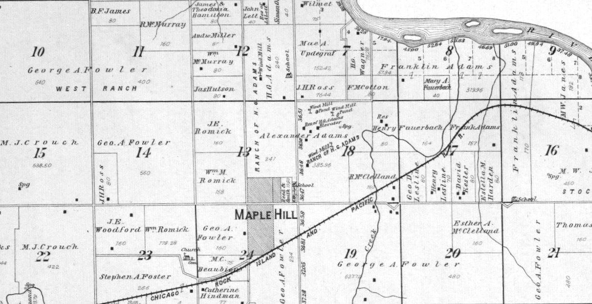
The 1895 Kansas Agricultural Census will show changes taking place. Alexander Adams is now 73 and his wife Mary Jane is 67. All of their children have now married and left their home. It is clear that while Alexander Adams still owned the original 655-acres of land, his occupation is now listed as landlord, which means that he is no longer actively farming his land. In fact, the 1902 Wabaunsee County Atlas clearly shows that while Alexander Adams continues to own the land, he has rented it to his son, Horace Greeley Adams. The 1902 Atlas shows the location of the Alexander Adams house, but now there are numerous dwellings and outbuildings shown on the land plot which are labeled Headquarters of the H. G. Adams Ranch.
Franklin Adams has now enlarged his property, has married, and moved l.5 miles to the north on a farm along the banks of the Kansas River. The census lists Franklin Adams, age 41, Elizabeth (Parsons) Adams, 33, Franklin A. Adams, 5, Arthur A Adams, 2, and Howard Adams 1 month. Franklin is shown owning 1,980 acres of land, and all of that land is fenced and/or improved. Of that amount, 600 acres is in cultivation and the remainder is pasture or timber. The value of the land is $20,000. Implements Franklin Adams owned were valued at $500. In 1894, Franklin Adams grew and harvested 1000 bushels of corn and owned cattle valued at $9,000. Clearly, Franklin Adams has now become an established farmer and small rancher in his own right.
The 1895 Census reports that Horace Greeley Adams, Sr. is 32, his wife Mable Gertrude (Warren) Adams is 30, and he has three children: Bessie age, 9, Rae age 6 and Helen age 3. Keep in mind that Horace G. Adams is renting his fathers 655 acres of land, and in addition, he owns 650 acres of land. Of that amount his is cultivating 400 acres. The land is valued at $25,000 with $200 in implements. Now the dramatic difference. He has grown or purchased 4,000 bushels of corn and he has cattle valued at $60,000. Horace Adams has made the decision that he will be a cattleman and is working towards that end. Its also clear that he does not own the land in Maple Hill Township to support the number of cattle that he is feeding for market, so he is renting or purchasing land elsewhere to do so. Even at this early time, his ranch headquarters is being used to feed cattle for market.
When the 1895 Census is taken, the transition of ownership of the George A. Fowler Ranch has begun to William John Tod, a Scot immigrant to was at first hired by Fowler to be ranch manager and then built and used his capital to buy ownership of the Fowler Ranch.
I have to stop at this point and interject a short story which was related to me by W. J. Tods granddaughter, Antoinette (Todd) Hawks. W. J. Tod was at one time president of the National Cattlemans Association, and a reporter asked him if his name had one d or two dds. Tod quickly quipped back, Son, if one d is good enough for God, its good enough for Tod! Sorry, I love that story.
W. J. Todd was shown owning 7,840 acres of land in Maple Hill Township, 900 acres were cultivated and the remainder was completely fenced pasture land. The land was valued at $100,000. On the cultivated land, Tod grew 900 bushels of oats, mainly for horse feed. He owned 150 head of horse (both saddle and draft) and he had 1200 feeding cattle, 120 hogs and 15 milk cows. All of these animals were valued at $103,000.
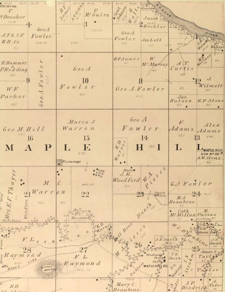
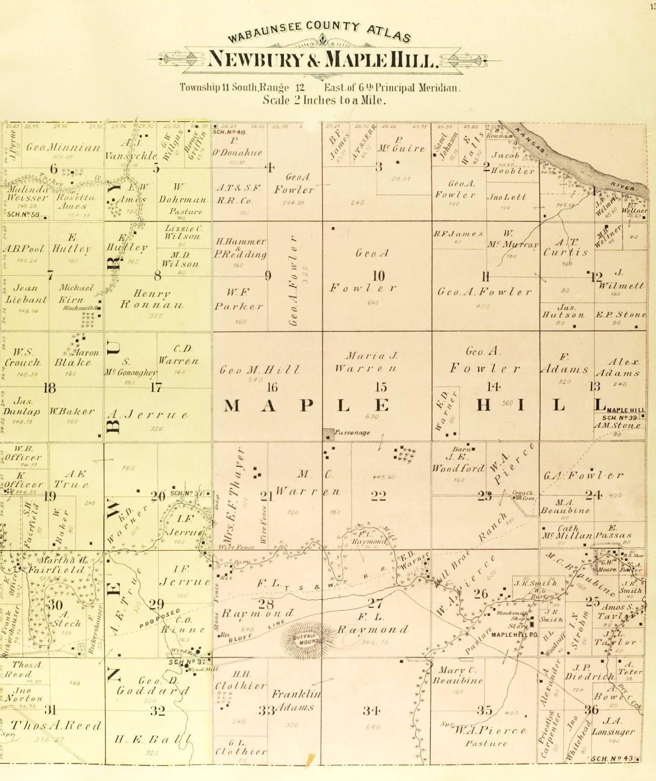
If one looks carefully at the images of the 1885 and 1902 Wabaunsee County Atlases, it’s quite evident that Franklin Adams is doing two things: He is acquiring land to develop his own farm and ranch, while he is also buying land, breaking the prairie for cultivated areas, fencing the pasture land and then selling the land to increase capital. There are parcels owned by Franklin Adams on the 1885 map that are not owned in 1902.
Incidentally, the Wabaunsee County Atlas images are from a wonderful website that is produced by the Kansas State Historical society. The address is: www.kansasmemory.org There are many interesting photographs of Maple Hill and Wabaunsee County people and items of interest on the site, which is free and a great use of your tax dollars!!
I want to again say that Im listing only a few of the dozens and dozens of farmers and ranchers in Maple Hill Township but it is clear that between 1870 and 1890, most of the land was settled and converted into farms and ranches. The population during that period of time went from 164 registered voters, to 1,190—and as youll remember, only men of legal age (21) could vote.
Ill stop there and continue with the history of the Alexander Adams family in the next post. As Ive mentioned earlier, I intend only to talk about Alexander, Mary Jane (Porter) Adams, and their four children through the 1920s. I will leave more contemporary generations to other writers.
Photo One, is taken from the 1885 Wabaunsee County Atlas. I’ve included it mainly to show property ownership of Alexander, Franklin and Horace Greeley Adams in Maple Hill Township, however it is interesting to also learn more about the other families that were settling in our township.
Photo Two, is an enlarged version of the image Photo One is taken from. This shows some of the Fowler Ranch and others. It would also help you locate the farm of Joseph Wilmett and the farms of the Warrens, Cheneys and Thayers.
Photo Three is from the 1902 Wabaunsee County Atlas and demonstrates that while Alexander Adams owns the land on which Horace G. Adams established his ranch headquarters, H. G. Adams is building a house and other structures to support his ranching operations. Also notice that the first frame school house, District #39, was built on a portion of the Alexander Adams land, as was District #84 to the north of the ranch headquarters.
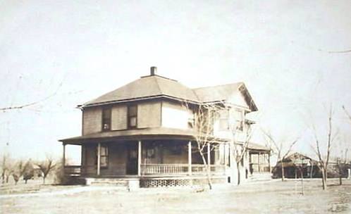
Photo Four, is a picture post card for the Horace Greeley Adams frame house, that was built directly across the road from the brick house presently occupied by Eddie and Peggy Adams. Jessie (Stewart) Adams (Ms. Raymond Adams Sr.) once told me that this house became infested with termites and had to be torn down. The termites were the reason why the brick house was built across the road.
I have not been able to find a photograph of the Alexander and Mary Jane (Porter) House, even though it was standing until about 1970. In the 1940s, 1950s and 1960s, it was used as a tenant house for workers on the H. G. Adams Ranch. I believe maybe one of the last families to live in the house was the Hydrick family. If you know of a picture, please let me know or scan it and put it on this page.


